TOUR 8
ROUTE MAPS
VIEW
TOUR 8
NEWS ARTICLE
VIEW

TOUR 8
NEWS ARTICLE
VIEW
TOUR 8
NEWS ARTICLE
VIEW
TOUR 8
NEWS ARTICLE
VIEW
 VIEW
VIEW
|
 |

Puerto
Rico is sixty miles west of Tortola, BVI. The wind in the Virgin
Islands blows predominantly, and heavily, east. Paddleboarders on
their way from Tortola to Puerto Rico will probably have the best
downwind romp of their lives. Hardcore souls may opt to paddle the
full sixty miles without stopping, but you will miss the unique people
and scenery of the Virgin Islands. A paddling tour from Tortola to
Puerto Rico visits three cultures: the British Virgin Islands, the
US Virgin islands, and—though the they belong to the USVI—the
Spanish Virgins that include Puerto Rico.
You can ship your board with Tropical Shipping
from Miami to the BVI. Tropical Shipping has an outpost in Los
Angeles that can truck your board to Miami. Mapcargo, a company
that operates out of Redondo Beach, CA, ships from both coasts
by land, air and sea to the Caribbean. If you fly your board make
sure it will fit on the plane! I learned the hard way that paddleboards
won’t fit on some aircraft.
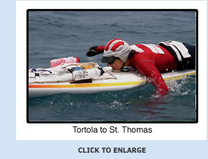
Though fun and scenic, paddling from Tortola to Puerto Rico is
no gimme. You will paddle in crowded waters, strong currents and
wind. You will cross two over twenty-mile channels: the 25-mile
Virgin Passage between St. Thomas and Culebra and the 26 miles
of open ocean that parallel the Cordillera, a necklace of islands
strung between Culebra (part of Puerto Rico) and “mainland” Puerto
Rico.
I suggest a chase boat in the Virgin Passage
and for Culebra to Puerto Rico. Possible chase boats for the Virgin
Passage can be found in boat-for-hire sections of St. Thomas tourist
publications. Local fishermen on St. Thomas could perhaps provide
a boat. For Culebra to PR, contact boat owners and marine businesses
in Fajardo, PR, or the anchorage in Culebra. If you solo, bring
plenty of water, food, waterproof charts, compass, GPS—and
your passport. A bike flag attached to the rear of your board will
make you visible to boat traffic.
 Customs and Immigration will see you as a
captain, and your board as a “ship underway”. Clear out and in with Customs and
Immigration EACH time you enter or leave a Caribbean country. On
Tortola, clear out at the ferry dock on West End. On St. John, clear
in at Cruz Bay; on St. Thomas, the ferry dock at Charlotte Amalie.
Customs and Immigration (See my story “Desiree”) can
end your trip by refusing to allow you to continue on. Customs and Immigration will see you as a
captain, and your board as a “ship underway”. Clear out and in with Customs and
Immigration EACH time you enter or leave a Caribbean country. On
Tortola, clear out at the ferry dock on West End. On St. John, clear
in at Cruz Bay; on St. Thomas, the ferry dock at Charlotte Amalie.
Customs and Immigration (See my story “Desiree”) can
end your trip by refusing to allow you to continue on.
Here is my account of crossing from Tortola to Puerto Rico:
In mid-May, threatened by a thunderstorm and strong wind, I crouched,
swathed in sun-protective Lycra clothing, dark goggles and Lawrence
of Arabia headgear on the sand blasted beach at Little Apple Bay,
Tortola. I loaded my dry bags with gear and stored them in a zippered
mesh carryall bolted to the deck of my board. I poked my red bicycle
flag onto the rear of my board. Shouting over the snapping of my
little safety flag, the rumble of thunder and the frenzied rustle
in palm trees of a twenty-two knot east wind (perfect for paddling
west to Puerto Rico), I counseled my son and sister-in-law on my
paddling route. My family had come to Tortola to support me. They
hoped to follow me in ferries and whatever boat they could find to
Puerto Rico
The wind pushed big dark clouds like heavy
furniture along the flat gray floor of the sky. Big raindrops exploded
against my face and the white fiberglass deck of my board. Eli,
a dark-haired strapping 36-year old, helped me carry my laden board
into the sea. My sister-in-law, Holly, a slim toned woman in her
late sixties (She had recently overcome a leg-shattering car crash
to again win big on the senior tennis circuit.) grinned at us from
the beach. Nervous but determined to succeed, I saluted my family
and my vertiginous desert island home, Tortola, and paddled west
toward Puerto Rico. The wind hustled me past Smuggler’s Cove,
a, pearl-sanded haven on Tortola for snorkelers. I felt apprehensive
and joyful about the weather, the dangers of my trip and the possible
glory of being first to paddleboard from Tortola to Puerto Rico.
 Whenever I paddle in the Caribbean, I try
to hang out in the beauty and grandeur of it all. I look up at
the stately palaces in the clouds. I ogle aquamarine water beneath
me—so luminous it must hold
the proverbial light at the end of the tunnel. I imagine myself reclining
on every dark shadow under the palm trees. I hope never to provoke
Caribbean ire: the violence of tropical storms, the avarice of drug
runners, the desperation of refugees from Cuba and Haiti, the mindless
power of speedboats, known as cigarette boats, captained by minds
set to appreciate only velocity over water and the possibility of
instant wealth. Some of these desperate critters hang out in the
VI’s most spectacular coves and beaches. I make it a point
to never approach strange boats anchored in idyllic spots with the
idea of discussing the weather or making friends. Whenever I paddle in the Caribbean, I try
to hang out in the beauty and grandeur of it all. I look up at
the stately palaces in the clouds. I ogle aquamarine water beneath
me—so luminous it must hold
the proverbial light at the end of the tunnel. I imagine myself reclining
on every dark shadow under the palm trees. I hope never to provoke
Caribbean ire: the violence of tropical storms, the avarice of drug
runners, the desperation of refugees from Cuba and Haiti, the mindless
power of speedboats, known as cigarette boats, captained by minds
set to appreciate only velocity over water and the possibility of
instant wealth. Some of these desperate critters hang out in the
VI’s most spectacular coves and beaches. I make it a point
to never approach strange boats anchored in idyllic spots with the
idea of discussing the weather or making friends.
I keep my eye also on the inter island ferries
whose captains want to get where they’re going quickly and are not known for their
compassion: A group of snorkelers capsized their dinghy off Big Thatch,
a small island west of Tortola. The swimmers waved desperately at
a passing ferry in the hope of rescue. The ferry captain tooted his
horn in salute and the passengers waved in greeting—as the
ferry swept past on its way to St. Thomas. Maybe, I tell myself,
the people on the ferry thought that the drowning snorkelers were
having fun. But, after fifteen years in the Caribbean, I am aware
of its dark side. Fortunately, the snorkelers were rescued by a fishing
boat.
Crossing the turbid two-hundred-yard-wide
channel (where the snorkelers almost drowned) between Tortola and
Big Thatch, I fell off my board in steep standing waves and strong
current caused by the meeting of wind and wave from the Drake Channel
and the Atlantic Ocean. Swimming, before I could re-mount my board,
I was overwhelmed by the wake of the “When” boat. This little ferry ambles several times
a day from Tortola to the neighbor isle Jost Van Dyke. It is named “When” because
it leaves Tortola “When” it wants to. The When boat exemplifies
Caribbean philosophy.
 The remains of an ancient volcano, the steep
island of Big Thatch is as covered with prickles as a porcupine:
all kinds of cactus and thorn bush thrive there. The island is
home to feral cattle, sharp-horned ferocious creatures that can
challenge intruders. Along with the island’s craggy steepness and opportunistic plants that leave
you with their clingy seeds, the fierce cattle say that Big Thatch
is theirs. Sharks love Big Thatch’s west end that rises Titanic-like
in a tall black final statement of the island’s end point of
land. As I ate and drank astride my board off Big Thatch’s
west end, I saw a medium-sized shark (species unknown) well up through
the dark water beneath me. The animal passed several time under my
board like a rodeo bull, then undulated off back to deeper water. The remains of an ancient volcano, the steep
island of Big Thatch is as covered with prickles as a porcupine:
all kinds of cactus and thorn bush thrive there. The island is
home to feral cattle, sharp-horned ferocious creatures that can
challenge intruders. Along with the island’s craggy steepness and opportunistic plants that leave
you with their clingy seeds, the fierce cattle say that Big Thatch
is theirs. Sharks love Big Thatch’s west end that rises Titanic-like
in a tall black final statement of the island’s end point of
land. As I ate and drank astride my board off Big Thatch’s
west end, I saw a medium-sized shark (species unknown) well up through
the dark water beneath me. The animal passed several time under my
board like a rodeo bull, then undulated off back to deeper water.
My next challenge was the Narrows, an eighth-of-a-mile-wide
channel between Tortola and St. John, USVI. The Narrows are part
of the Drake channel that parallels Tortola and a string of neighbor
islands to the north. The Narrows dangerously concentrates diverse
boat traffic—cargo
vessels, container ships, sailboats, cigarette boats and ferries—that
makes its way between the BVI and the USVI. Amazingly, the ferry
that was bringing Eli and Holly to meet me on St. John passed me
just as, panting and adrenalized, I reached the north coast of St.
John on my paddleboard. Eli later told me that he had cautioned the
ferry captain, “There she is! Don’t hit my mom.”
 Relieved to escape the Narrows, I paddled
in to a spacious bay on St. John’s north coast. I appreciated the island’s beauty.
Mostly a national park, St. John—though generously discovered
by the cruise ship set and hippie types, who (I love them for this!)
think that the sixties must be preserved in their long hair, beads,
and the peace sign—is a citadel of nature. Its pure beaches
and tangled jungles, still raucous with birds, are iconic to tropics
lovers. East of St. John’s bustling commercial hub, Cruz Bay,
are tranquil bays like Maho Bay and Cinnamon Bay. Both have campgrounds. Relieved to escape the Narrows, I paddled
in to a spacious bay on St. John’s north coast. I appreciated the island’s beauty.
Mostly a national park, St. John—though generously discovered
by the cruise ship set and hippie types, who (I love them for this!)
think that the sixties must be preserved in their long hair, beads,
and the peace sign—is a citadel of nature. Its pure beaches
and tangled jungles, still raucous with birds, are iconic to tropics
lovers. East of St. John’s bustling commercial hub, Cruz Bay,
are tranquil bays like Maho Bay and Cinnamon Bay. Both have campgrounds.
I spent the night with Holly and Eli in a
tent in Maho Bay. We refueled in the campground’s adequate, cat-infested restaurant and slept
like stones until morning—when we resumed our roles as athlete
and support team. I would paddle on to St. Thomas, where Bolongo
Bay, an all inclusive resort, had agreed to put me up for a pro bono
night. Eli and Holly planned to pursue me to St. Thomas in a ferry.
The wind seemed stronger. As I set out from Maho Bay, I lost myself
in the striations of the muscular sea. Purple-black with wind, the
water galloped so hard that flecks of white foam appeared on its
limbs like sweat on the flanks of a racehorse.
Passing the relatively calm entrance of Cruz
Bay, St. John, I joined a herd of elderly (my age!) kayakers out
with their guide on a tour of Cruz Bay. Soothed that I had at last
joined my species—folks
paddling around in the sea—I then set myself apart by informing
my newfound tribe that I was on my way to Puerto Rico. “Do
you know,” I asked my audience that looked aghast with open
mouths and bulging eyes to learn of my plans, “how to get through
the St. James Island cut?”
As crucibles go, I saw that the St. James
Island cut, off the west end of St. John and between St. Thomas
and a small out island named St. James, might be the worst problem
that I’d encounter enroute
to Puerto Rico. In order to reach the west coast of St. Thomas, most
boat traffic passes through the St James Island cut, a ravenous slot
filled with conflicting waves, current and confused boats. The mere
thought of threading the perilous eye of this needle on a vessel
as small as a kayak had the Cruz Bay kayakers paddling away from
me. They ignored me, as polite politically correct folks ignore a
grisly car crash.
 On my own, I wondered how to proceed through
the St. James Island Cut. At the mouth of the cut I saw a large
swaying buoy. I figured that boats—I counted three ferries, a cigarette boat, a cargo
vessel laden with cars, and a small container ship—vying to
be first through the cut, would not want to hit the buoy, and thus
would avoid me. If I could hide behind the buoy, it would give me
a safe vantage point from which to plot my next move. When I saw
a window in the charging boat traffic, I closed my eyes and sprinted
toward the buoy. On my own, I wondered how to proceed through
the St. James Island Cut. At the mouth of the cut I saw a large
swaying buoy. I figured that boats—I counted three ferries, a cigarette boat, a cargo
vessel laden with cars, and a small container ship—vying to
be first through the cut, would not want to hit the buoy, and thus
would avoid me. If I could hide behind the buoy, it would give me
a safe vantage point from which to plot my next move. When I saw
a window in the charging boat traffic, I closed my eyes and sprinted
toward the buoy.
Feeling that it was log graciously offered to me to prevent my sure
drowning, I clutched at the buoy. It and me became the point of divergence
for oncoming boats. I saw that the best way to avoid the boats and
current (it reminded me of class five rapids) would be to quickly
attain, then hug the south coast of St. Thomas. I reached St. Thomas,
which is about fifteen miles from Tortola, by paddling as fast as
a speed boat and maximally risking my life. I began to poke along
the west coast, which is civilized enough to require, by placing
conspicuous red buoys, that boat traffic stay four hundred yards
offshore. Bolongo Bay was still twelve miles away.
Bolongo Bay teemed with avid vacationers.
I was buzzed by jet skis, avoided by windsurfers and sailboats,
and hailed by snorkelers. Bolongo Bay could be negatively described
as a stereotypical all-inclusive resort, but I felt warmed by the
staff’s friendly greeting
and the enthusiasm of my son and sister-in-law. After an interlude
of greasy food, air conditioning, TV, and a view of beach umbrellas
that sheltered the large abdomens of the indolent, I was ready to
tackle the Virgin Passage, then on to Culebra and Puerto Rio
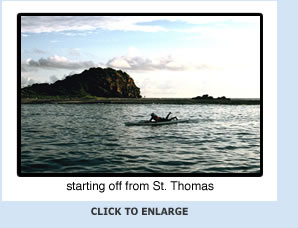
 I picked up my first chase boat outside Botany
Bay on the extreme west tip of St. Thomas. On an island known for
violent crime, racial tension, traffic congestion—and fondly called Little New York—Botany
Bay, with its lack of hotels and its thriving marine ecosystem, is
St. Thomas’s respite from civilization. I was lucky to get
a support boat for the Virgin Passage from a St. Thomas surf-related
business. My boat captain, a powerfully built grinning islander,
was eager to see me set off on my 25-mile traverse of the Virgin
Passage. I started out from a small beach and paddled toward the
low distant V of land that was Culebra. I picked up my first chase boat outside Botany
Bay on the extreme west tip of St. Thomas. On an island known for
violent crime, racial tension, traffic congestion—and fondly called Little New York—Botany
Bay, with its lack of hotels and its thriving marine ecosystem, is
St. Thomas’s respite from civilization. I was lucky to get
a support boat for the Virgin Passage from a St. Thomas surf-related
business. My boat captain, a powerfully built grinning islander,
was eager to see me set off on my 25-mile traverse of the Virgin
Passage. I started out from a small beach and paddled toward the
low distant V of land that was Culebra.
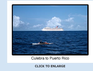
With the east wind and the westbound current
behind me, I moved along at a fast four knots. My family bolstered
my strength by offering me water and food in a long handled fishnet.
Icons of danger—a
cruise ship and a container vessel--loomed like icebergs on the horizon
but kept their distance. I felt safe and accomplished paddling in
to Ensenada Honda, a deep cleft in the island of Culebra. Holly,
Eli and I stayed in one of the colorful little inns that line the
shore of Ensenada Honda. Culebra is a comfy little place with none
of the hustle of its neighbor St. Thomas, or the impersonal size
of Puerto Rico.
Culebrians are proud of Dewey, their picturesque
laid-back village. They enjoy their national park that preserves
nature by encouraging volunteers to uproot non-native plants and
to fence off turtle egg-laying spots from trampling feet. Despite
their distaste for non-green visitors, Culebrians make visitors
feel like one of their own. In the evenings, a karaoke bar in Dewey
eagerly exports its fun and songs. People on boats anchored in
Ensenada Honda and Dewey’s residents sing
along with the karaoke singers from their boats and houses—until
the island is one big party singing the same song.
Paddling under the bridge that connects Ensenada
Honda and the town of Dewey to the open ocean between Culebra and
Puerto Rico, I felt sad to leave Culebra. On the ocean side of Dewey,
I met my second chase boat, a sleek sailing ketch. A gray-bearded
veteran of many ocean miles and his darkly tanned young girlfriend,
both natives of Puerto Rico, captained it. My gear was loaded the
night before, and Eli and Holly were already aboard. I had found
the boat by talking around in marinas and chandleries on Tortola.
A Tortolian business owner had friends in Puerto Rico, one of which
was eager to sail from PR, meet me in Culebra and escort me on to
Fajardo.
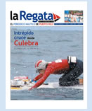
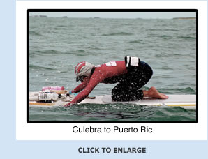
Culebra to PR was the most exciting part of my trip. Not
only were the views of the Cordillera, the silver-sanded, uninhabited
string of islets that link Culebra to PR, spectacular, but also the
weather challenged me. Caribbean wind almost never blows west, but
the big thunderstorms born in the vigorous thermals over the tall
mountains on PR can reverse weather pattern. The first half of my
paddle was done aided by easterly trade winds and mild seas. During
my last thirteen miles, towering clouds let down gyrating waterspouts
and hurled sharp spears of lightning. The west wind tore off the
tops of waves and flung them in my face. Seeing me fatigued and in
danger, Holly and Eli encouraged me to come aboard.
I did not want to disappoint my boat captain.
He was a hardcore mariner and a fiercely competitive racing sailor.
Under his exacting gaze, I soldiered on in worsening weather toward,
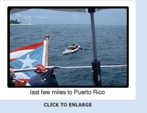
the dark rain shrouded bulk of Puerto Rico. When I reached Isla
Palomino, a resplendent tiny island four miles east of PR and popular
with weekend boaters, I knew that I’d reach the mainland.
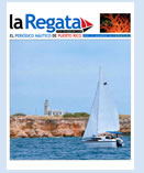
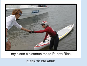
Arriving in Las Croabas, a small cove near
Fajardo, PR’s main
marina, I was met by the press from La Regata, PR’s nautical
newspaper and friends of my boat captain. Seeing grinning faces—my
captain, his pretty girlfriend and my family—above the blue
and red, single-star flag of Puerto Rico that flew from the stern
of my chase boat, I felt totally drained but proud—and already
in love with the tall, proud green island called Puerto Rico.
|
|